Greeting Vic:> Using GPS Rwy 9 Plate for KSAN - map area shows SARG intersection - just
> to the right it shows 2000 NoPT 092deg ( 4.5)
It looks like they’ve eliminated the NDB or VOR GPS RWY 9 approach and made it a NDB RWY 9 approach and issued a separate GSP RWY 9 approach. I’m posting the new NDB RWY 9 plate as it seems the portions you’re referring to are the still the same. I’ll post the new GPS 9 approach at the bottom of the message.
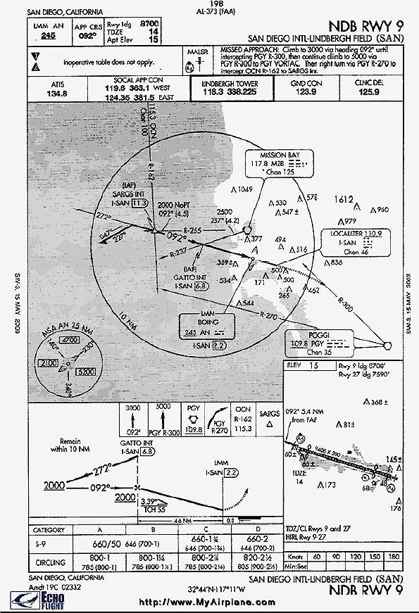
> as I recall that means minimum alt is 2000, course (localizer) is
> 092degActually, on a GPS approach, it's a GPS course and not the localizer. While GPS and ILS final approach segments may be identical, they aren’t always the same. The reason why GPS course and ground based NAVAID radials and localizers sometimes have different numbers is because magnetic variations change, but the NAVAIDs are not re-alligned to reflect these changes.
> , 4.5 miles to intercept glideslope and - this is what puzzles me
> -NoPT I thought meant No Procedure Turn - yet a PT is shown on the map
> and the graphic - what am I missing.
Let's review the basics: Procedure turns are mandatory for all published terminal arrival routes (the thick lines as opposed to the thin radial lines that identify fixes and do not depict distance and altitude). The only times you’re not authorized to make the procedure turn is unless vectored to final, leaving a hold for a timed approach, NOPT (NO Procedure Turn) is specified or ATC tells you not to make it. Please see 14 CFR 91.175, sub paragraph (j) for the specific wording.
You may recall that unless vectored, you must transition from enroute navigation to terminal route through an IAF (Initial Approach Fix). At SAN, the IAF’s are GATTO and SARGS. Because the terminal arrival route from SARGS (which typically requires a procedure turn because all terminal arrival routes require them unless one of the above is met) also crosses another IAF--GATTO, the NOPT notation is shown. Otherwise, the incorrect interpretation/assumption is a procedure turn would be also required at GATTO.
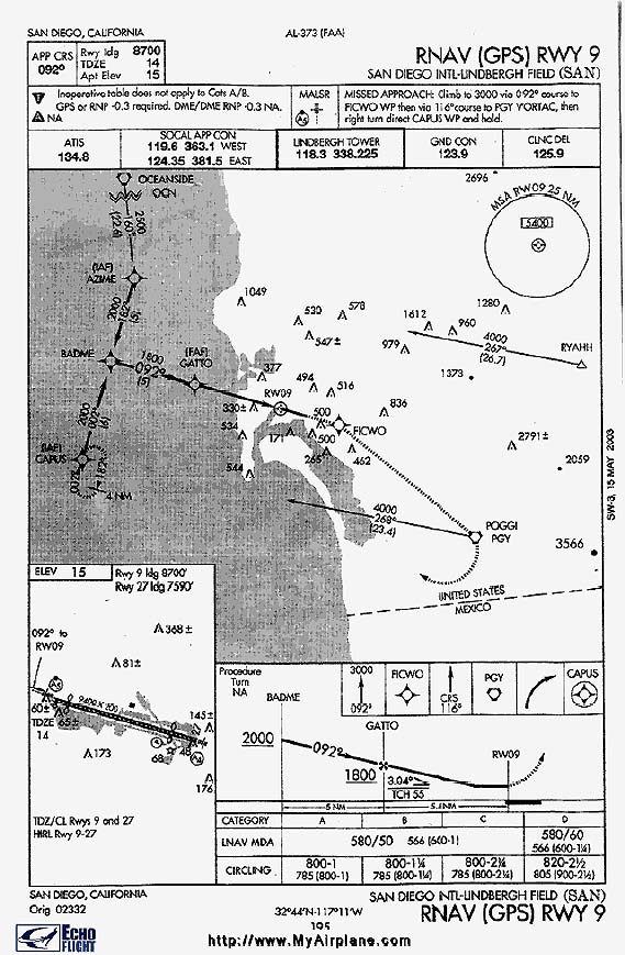
Here’s the new GPS 9 approach to KSAN. Just FYI, this is a good example of how GPS approaches will be depicted in the near future.
> 2nd question - when I was flying IRL they didn't have GPS approaches. I
> notice that some approaches are 'approved' GPS approaches and others
> not. Why the difference?
All approaches are categorized as being either precision or non-precision approaches (the difference being the vertical guidance component/glideslope being present or not). Up until July 10, 2003 when the FAA turned on the WAAS (Wide Area Augmentation System) that provides a vertical component (now called a glidepath in GPS systems) for GPS approaches, all GPS approaches were non-precision. Therefore, no precision approaches could be GPS approaches.
> Also, while I'm on a roll - am I correct in
> assuming that the GPS is used just to get you to a certain fix and the
> pilot takes over from there and follows the plate procedure?
I’m not understating your questions. If you’re talking about flying direct, then yes. You can fly direct using GPS (in the real world an IFR-certified GPS) to an IAF. From there, you’d fly the approach.
> Just trying to keep the old brain cells active<G>.
No problem. Hope this helps!
Ben


 Printer-friendly
version of this topic
Printer-friendly
version of this topic Bookmark this topic
(Registered users only)
Bookmark this topic
(Registered users only) FSFORUM
![[Sysop]](http://www.flightadventures.com/Forum/htdocs/dcforum/Images/3bar.gif)


![[Admin]](http://www.flightadventures.com/Forum/htdocs/dcforum/Images/4bar.gif)